CleanSeaNet Service

CleanSeaNet is a European satellite-based oil spill and vessel detection service which offers assistance to participating States for the following activities:
- Identifying and tracing oil pollution on the sea surface;
- Monitoring accidental pollution during emergencies;
- Contributing to the identification of polluters.
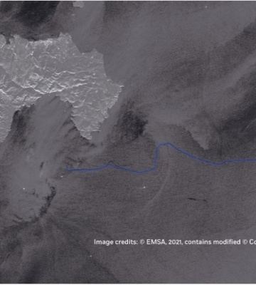
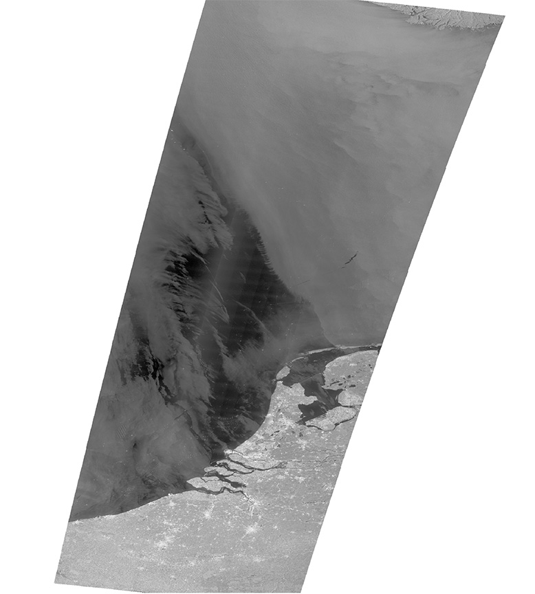
The CleanSeaNet service is based on the regular ordering of Synthetic Aperture Radar (SAR) satellite images, providing night and day worldwide coverage of maritime areas independent of fog and cloud cover. Data from these satellites is processed into images and analysed for oil spill, vessel detection and meteorological variables.
The information retrieved includes, among others: spill location, spill area and length, confidence level of the detection and supporting information on the potential source of the spill (i.e., detection of vessels and oil and gas installations). Optical satellite images can also be acquired upon request, depending on the situation and user need.
A user-focused service
In cooperation with users, EMSA’s Earth Observation team plans and orders satellite imagery to meet their service coverage requirements. After image acquisition, trained operators assess the images together with supporting information (meteorological, oceanographic, and ancillary information such as AIS and vessel detection) to identify possible pollution events, to determine the likelihood of the presence of oil on the sea surface, and to assist in identifying the source of the pollution.
When a possible oil spill is detected in European waters, an alert message is sent to coastal States. Analysed images are made available to national contact points in near-real time and are sent to the relevant national authorities who then follow up on the alert report.
© EMSA, contains modified Sentinel-1 (data obtained via Copernicus): “© Copernicus Sentinel data [2023]”
CleanSeaNet’s near-real time service capabilities are crucial to a rapid response by coastal states as well as to increase the likelihood of catching the polluter red-handed. In case of oil spill related accidents or emergencies the affected coastal State can request additional satellite images to monitor the spill area over an extended period of time, capturing the evolution of the spill and supporting response and recovery operations.
Added value services
The CleanSeaNet service is available to all participating States including EU Member States and their overseas territories, candidate countries and EFTA Member States. Each coastal State has access to the CleanSeaNet service through a dedicated user interface, which enables them to view ordered images. Users can also access a wide range of supplementary information through the interface, such as oil drift modelling (forecasting and backtracking), optical images, and oceanographic and meteorological information.
Related Documents
- Successful launch of Copernicus Sentinel-1D
- Copernicus Sentinel-1C slated for lift-off on December 4, 2024
- CSN NCAs contact details
- CleanSeaNet - Detections and Feedback data (2015-2024)
- CleanSeaNet Services Catalogue (2023)
- Earth Observation services infosheet - Supporting Rescue Coordination Centres
- CleanSeaNet - European satellite based oil spill monitoring and vessel detection service
- Copernicus Maritime Surveillance - Product Catalogue
- CleanSeaNet Service - Detecting Marine Pollution from Space
- Copernicus Maritime Surveillance - Info sheets
- Copernicus Maritime Surveillance - Service Overview
- Automatic Detection and Alert Triggering of Ship Behaviour [leaflet]
- Celebrating the CleanSeaNet Service. A ten year anniversary publication
- Integrated Maritime Policy and the SafeSeaNet Ecosystem
- The CleanSeaNet service
- Addressing Illegal Discharges in the Marine Environment
- Integrated Maritime Service Brochure
- CleanSeaNet First Generation Report
- Using satellites to improve maritime safety and combat marine pollution [leaflet]
- EMSA view on the GMES programme of EU and ESA
- CleanSeaNet [2007 leaflet]
Featured Copernicus & CleanSeaNet Publications