How SafeSeaNet Works
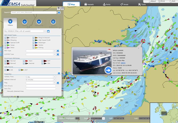 SafeSeaNet graphical interfaceThe first thing that most users see when accessing SafeSeaNet is the web interface. It is a map-based graphical interface (GIS), and it is this that makes the system easy to understand and operate, and that makes it possible for users to quickly obtain what they need. Users have the capability to zoom in and out to display the images from EU-level to individual quays in ports. They can also view historical vessel positions and obtain selected information on ships in a number of different ways. The information is presented on high-quality nautical charts containing a range of useful maritime information.
On the technical side, the core of the SafeSeaNet architecture is the EIS (European Index Server). This acts as a secure and reliable index system within a "hub and spoke" network (including authentication, validation, data transformation and logging) which sends requests to, and receives notifications and responses from, approved users. Users can provide and/or request data.
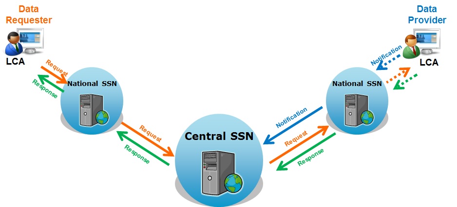 SafeSeaNet system - information exchange
The EIS is able to locate and retrieve information on vessels related to one Member State in response to a query or request made by another. The information exchanged is extensive, but the main notification reports submitted to SafeSeaNet are as follows:
• Ship Notifications: These are used to provide SafeSeaNet with voyage and cargo information. Notifications are based on two types of message. Automatic Identification System (AIS) messages are sent automatically by the ships through very high frequency (VHF) radio signals, and received by coastal stations within range. Mandatory ship reporting systems (MRS) can be established by governments, with approval from the International Maritime Organization, for certain types of vessel transiting through defined areas. MRS messages are sent by ship masters to coastal stations. Information includes ship identification, course, speed, and cargo.
• Port Notifications: These are used to notify SafeSeaNet when vessels arrive and depart from ports. The estimated time of arrival, actual time of arrival, actual time of departure and the number of persons on board are included in the message.
• Hazmat Notifications: These are used to notify SafeSeaNet that vessels are carrying hazardous materials (dangerous or polluting goods) on board, and that the data provider has detailed information on these goods.
• Incident Reports: These are used to provide SafeSeaNet with information on incidents involving ships. These might be related to ship safety and seaworthiness (e.g. collisions, groundings, equipment failures), the environment (e.g. pollution incidents) or other pre-defined categories (e.g. banned ships, ships not reporting according to rules).
• Waste Notifications: These are provided to users via SafeSeaNet in compliance with the EU Reporting Formalities Directive, and they allow interested parties to find out the different types of waste on board, and when and where they are to be discharged.
• Security Notifications: These are also provided to users via SafeSeaNet in compliance with the EU Reporting Formalities Directive, and they provide information on security issues that relate, in particular, to avoiding the ship being used as a weapon.
The EIS provides two different interfaces to enable users to exchange messages: 1) the XML message-based interface, which enables the applications of Member States to communicate programmatically with the SafeSeaNet system (i.e. information is automatically exchanged between systems), and; 2) the browser-based web interface, which provides a pan-European vessel traffic image and enables users to visualise information stored in the EIS.
Related Documents
- Automatic Detection and Alert Triggering of Ship Behaviour [leaflet]
- Reporting Hazmat in SafeSeaNet: Obtaining accurate information on dangerous and polluting goods on board ships
- National Single Window Prototype - an electronic solution for simplifying administrative procedures
- Integrated Maritime Service Brochure
- Blue Belt Pilot Project - Evaluation Report
- SafeSeaNet - Vessel Monitoring System Synergies Pilot Project
- Blue Belt Pilot Project
- Sharing the European Vessel Traffic Image and Beyond [leaflet]